It's a strange thing to be in a foreign landscape. A lot of odd details stick out - about people's behavior, about the laws and politics, about the architecture, about the plants and animals and even the insects (there are mosquitoes in Ireland). It's hard to know what to focus on, let alone what to make of it.
Like any short-term visitor, I have no doubt that my observations are shallow and distorted, but they are genuinely mine, and the experience was significant to me. The following is a sketch of my impressions and ruminations and my reading of the landscapes I saw.
Irish Itinerary - 10 days, 4 cities, 500 miles. Travel May 22 to June 2.
Cead mile failte romhat! (A hundred thousand welcomes!)
My stand-out impressions
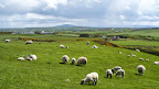
The landscape, and especially the rocks. Lots of open fields of short grass, rolling hills, sheep, and trees few and far between. Rocky in the southwest, especially along the coast. Steep cliffs plunging to the Atlantic. Rocks are the thing here, from volcanic curiosities, to neolithic and medieval ruins, to the web of stone walls in the Gaeltacht and Burren regions. Hillier and less rocky in the north, with more trees (but still not much). One of the students in our group asked our bus driver PJ about animals in Ireland. PJ said, "Mostly little animals - rabbits, squirrels, badgers - all living in harmony and eating each other."
 |
 |
 |
| Cliffs of Moher | The Burren | Giant's Causeway |
Ruins and relics. The megalithic ruins in Ireland predate Stonehenge or the building of the pyramids in Egypt. The Hill of Tara and Newgrange sites go back more than 5,000 years. Put your hand (or foot) on Lia Fáil ("the Stone of Destiny") at the Hill of Tara and listen for the roar that declared the High Kings of Ireland until 500 A.D. (didn't work for me). Ireland's Christian roots go back a bit too - to the 5th century. As the Roman Empire collapsed and Europe slid back into the "Dark Ages", monks in Irish monasteries scribbled away to preserve ancient texts, giving us the illuminated Book of Kells, and their ruined, stone monasteries (some ruined by neglect, others by the bloody English).
 |
 |
 |
| Celtic High Cross, Inishmore island | Stone of Destiny, Hill of Tara | Round Tower, Glendalough |
Weather. Late May into early June, and I think I took my jacket off once in ten days. According to the locals, if it isn't raining sideways, then it isn't really raining. Enjoy.
 |
 |
 |
| Wind at Cliffs of Moher | Rain at Dun Aengus | Cool in Glendalough |
Irish wit. Everybody's a comedian here.
The Linguistic Landscape

Everyone in Ireland speaks English. But not everyone speaks Irish, at least not fluently. The word "Irish" is a shibboleth in Ireland - referring as much to the Gaelic language as to the quality of being from Ireland. I was told that if you ask someone if he speaks Gaelic (rather than Irish), he'll know you're not Irish (as if your accent wouldn't tip him off). The Republic of Ireland is a bilingual country. All public signs are printed in Irish (or Gaelic) first, and then in English. Interestingly, I noticed that no commercial signs were in Gaelic ... I mean Irish. Irish language is a compulsory subject in the state education system in the Republic of Ireland. Almost all Irish speak some Irish, and facility with the language is a point of pride.
Ni tir gan teanga (No nation/land without a language)
Restoring the Irish language, and culture, has been a national project since the late 19th century. One of the first things the Irish Free State did after gaining independence from the UK in the mid 1920s was to establish the Gaeltacht - special districts where the government recognizes that the Irish language is the predominant (or at least a significant) language. Most of the Gaeltacht are found along the western coast of the island, in areas that are largely rural, and unsurprisingly, less economically vibrant. We passed through some of these areas in Galway County on our day trip to Inishmore. The countryside we saw around Spidel was covered in a complex web of dry stone walls, small plots of land, interspersed with stone cottages, some with thatched roofs.  Although quaint and even romantic, the ubiquitous stone walls are actually an indicator of the poverty of the land. The stone walls were as much about removing stones to make the land cultivable as marking properties. The Gaeltacht suffer problems similar to a lot of rural areas - lack of economic opportunity and loss of population due to out-migration of their young people looking for work and a better life. This is on top of the persistent pressure of maintaining a minority language in a predominantly English-speaking country. Recent government reports suggest that the Gaeltacht boundaries are too large, no longer encompassing areas that are actually Irish-speaking. But the idea of shrinking those boundaries is emotionally repugnant to the Irish, and it also faces economic resistance. While the traditional rural economy of these areas is rapidly fading, it has been replaced to some extent by a cultural cottage industry devoted to teaching Irish and providing opportunities to engage with traditional Irish culture and crafts.
Nil Gaeilge maith agam (I don't speak good Irish)
The Political Landscape
Ireland is an island divided by visible and invisible borders. Despite its small size, memory and history of the divisions are thick here. 
At 32,595 square miles, the island of Ireland is smaller than Maine and slightly larger than South Carolina, but with a population less than that of Massachusetts (a state 1/3 the area). Ireland sits west of the island of Great Britain, separated by the Irish Sea, but not entirely separated. The northern one-sixth of the island, Northern Ireland, is part of the United Kingdom (along with England, Scotland and Wales), while the rest of the island is the independent Republic of Ireland - has been since 1922. Ireland was officially part of the United Kingdom between 1801 and 1922, although it had been invaded and occupied by the British repeatedly since the 12th century. When Irish republicans declared their independence from the UK in the early 20th century, the British loyalists in Northern Ireland (descendants of English and Scottish protestants planted there beginning in the 16th century) opted to stay a part of the UK - much to the annoyance of Irish nationalists, especially that minority living in Northern Ireland. As with any separation, there was bad blood all around. However, violence flared in a big way in the 1960s as Irish nationalists of Northern Ireland battled with their loyalist neighbors and British authorities over issues of discrimination and oppression, cultural and political autonomy, over identity. By the early 1970s, British troops were sent in to re-establish state control. "The Troubles" lasted until the late 1990s, when the Good Friday Agreement (1998) established a system of greater autonomy for Northern Ireland which included power-sharing between Irish nationalist (or Catholic) and British loyalist (or Protestant) communities. In 2005, the Irish Republican Army announced the end of its armed campaign and initiated disarmament. Eight years later, there we were, riding in a tour bus full of students and faculty, into what had been a war zone.
 The border between the Republic of Ireland and British Northern Ireland is unmarked. It's less apparent even than the border between the US and Canada. No border patrol or checkpoints. Not even signs letting you know that you've crossed between sovereign territories. Smooth blacktop zips you through bucolic, rural countryside from one isolated community to another. Road signs do change. Ireland is officially bilingual, and all public signs are printed first in Irish (or Gaelic, as the non-Irish say), and then in English. In Northern Ireland, it's all English. Ireland uses the metric system (e.g. kilometers), while Northern Ireland uses English units (e.g. miles) - which can make the speed limit treacherous. Although, from an American perspective, they both drive on the wrong side of the road, so maybe it doesn't matter. Ireland is part of the European Union, and therefore uses the Euro for currency. Northern Ireland currency is based on the British Pound Sterling (£). However, Northern Ireland banks issue their own bank notes, and although they are technically Pound Sterling, are nearly impossible to exchange anywhere outside of Northern Ireland (including the UK!). Luckily, most places in Northern Ireland accept the Euro (and the ATMs dispense Euros by default). Both Ireland and Northern Ireland speak English, but the Northern Ireland accent is distinctly different - and was often quite difficult for me to understand. I kept having to ask people to repeat themselves (which made me feel silly and apologetic).
 While there are no apparent physical borders between Ireland and Northern Ireland, the remnants of division are real enough. Memories, especially, seem raw. PJ, our bus driver/tour guide (a man from Cork, the south of Ireland), repeatedly reminded our group to enjoy the visit, but to watch ourselves and avoid political conversations - or any dispute we had no business being involved in. The strange thing is that political disputes are exactly the draw of a place like Northern Ireland. In Derry (or Londonderry to loyalists and the British), the old 17th century walls (20 feet thick in some places) are immovable testimony to centuries of conflict and hostile separation between British settlers and the native Irish. Indeed, these same walls were used in the 1970s and 1980s by British troops to monitor and maintain control over hostile, Irish nationalist neighborhoods. But it's the murals that really catch your eye.
When visiting Derry/Londonderry, you must visit the Bogside neighborhood. It's a majority Catholic (i.e. Irish nationalist) neighborhood just outside the old city walls of Derry. It's covered in gable-wall murals commemorating The Troubles. The themes range from galvanizing pictures of invasion and resistance, to sad memorials of lives cut short, to hopeful signs of peace. It's a major tourist attraction. While the surrounding hills are covered in nearly uniform rows of modern houses, Bogside itself apparently hasn't changed much, either architecturally or attitudinally. It looks like a quiet, working-class neighborhood, but by all accounts, it's still a hotbed. It sits next to the majority-protestant Fountain neighborhood, which has been a constant source of friction. As recently as 2011, Derry was rocked by riots, centered on the Bogside. Indeed, some say that the The Troubles started here, but they reached their culmination in Belfast - our next destination.
 |
 |
 |
| Operation Motorman | Death of Innocence | Petrol Bomber |
At the height of The Troubles, Belfast was compared to Beirut on a bad day. Much of the city was destroyed by bombs and fires, and has since been rebuilt. There are significant areas of the surrounding neighborhoods that have yet to recover. The Troubles are still more than just a memory, and as one local told me, "everything is political here." Belfast has murals too - in greater abundance and spread more evenly between Irish nationalist and British loyalist sentiments. Interestingly, our guide seemed much less comfortable in making time for us to get off the bus and look more closely. This was especially the case in the loyalist neighborhoods. I was told by a couple of Irishmen that the people in Northern Ireland, and especially Belfast, have an "edgier" air, which they attribute to the trauma of decades of conflict and violence. But our encounters with people there were entirely positive, and we wandered. Still, security is no joke here. During a drive through a loyalist neighborhood of Belfast, one of the students on our tour asked PJ how big the police force was. PJ replied, "Let me see, about six-foot."
 |
 |
 |
| Belfast murals |
Unlike Derry, Belfast seems to be asserting greater control of its image and not allowing itself to be defined by The Troubles. The city center boasts elaborate Victorian architecture, much of it repurposed to modern ends - high end restaurants, pubs and shops. The city has made much of the anniversary of the infamous RMS Titanic, which was built here, along with thousands of other ships. The new Titanic Belfast visitor center is located on the site of the former Harland and Wolff shipyard in the city's Tianic Quarter. The ultra-modern, super-interactive center tells the story of Belfast's industrial and maritime heritage, but is heavily focused on the story of the Titanic. I found the back-story to Belfast's rise as an industrial center to be fascinating, but I have to admit that I'm of a generation that was over-saturated with Titanic-mania and I couldn't get out of there fast enough.
 |
 |
 |
| Queens College, Belfast | Belfast Botanic Gardens | Belfast City Hall |
 From what I could glean from the few Irish I spoke with, Northern Ireland is not yet a popular tourist destination for folks from the Republic of Ireland. According to PJ and others, very few Irish are at all familiar with Northern Ireland. Such reticence does not seem to have affected the international community. Tourism is clearly on the rise. Derry was completely disrupted (happily) by a massive pop music concert that was drawing talent and attendees from around the world. A few days after we left, Belfast was hosting the G8 Summit. No worries about security there. Neenah and I did stumble upon at least one sign of resistance and protest in Belfast, but it was aimed outward rather than inward.
Slán agus beannacht leat (Goodbye and blessings on you)
No comments:
Post a Comment